The weight carried by an atlas
Cartographer Peter Fretwell demonstrates how profoundly the story of the Antarctic has become the story of the rest of the world. His beautiful work offers a unique perspective on the world’s most unknowable continent.
Words by Rachel Halliburton // Maps by Peter Fretwell
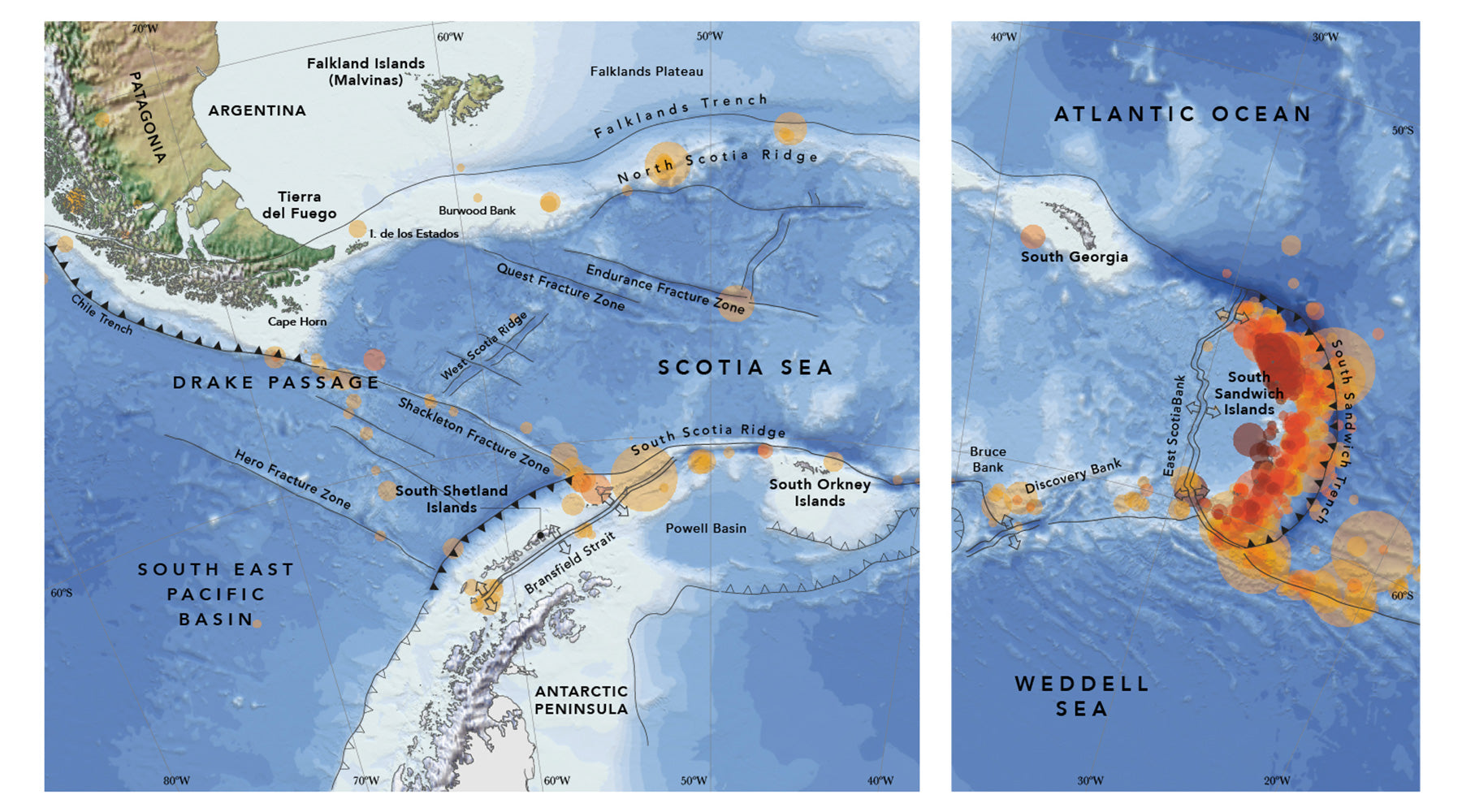
“It’s February 2018, and I am sitting in a bright orange tent, pitched on a glacier 12 kilometres wide. This frozen river of ice, the Sibelius Glacier, is located in the centre of Alexander Island, Antarctica’s largest island and the second largest uninhabited island on earth. Very few people have been here before, and tomorrow my field assistant and I will ski south to explore and investigate part of a small range of hills that no one has yet visited. A place where no human feet have yet trodden. There are fewer and fewer places where this claim can be made.”
This resonant first paragraph opens cartographer Peter Fretwell’s austerely beautiful and minutely fascinating Antarctic Atlas: New Maps and Graphics That Tell the Story of a Continent. Whether you’re more interested in the flight paths of albatrosses or the shifting tectonic plates beneath the sea, Fretwell’s work is a rich mine of detail. “Part of the beauty of maps is that they bring science and art together,” he says on a Zoom call from his home near Cambridge. “You have a real responsibility because maps are powerful, and people are more likely to believe them than they will believe a graphic or written text.”

Fretwell has worked for the British Antarctic Survey for almost 20 years. In order to make his maps he has talked to glaciologists, oceanographers, geographers, historians, logistics experts, modellers, ecologists and geophysicists. “Over the years, as the analysis becomes more complex and the techniques I use more original, my job has changed from cartographer to scientist,” he writes in the atlas’s introduction. When he and I are talking, though, what’s equally clear is that he sees the maps as a potent device for relaying important stories. “When I started to think about what maps I should put in there,” he says, “there were things I knew through my conversations with experts that really needed to be told to the general public, rather than just being published in a scientific paper.”
Like so many people whose work is defined by the Antarctic, the story of Fretwell’s career is also the story of a love affair with its landscape. “When you go there for the first time it feels life-changing,” he declares. He as much as anyone else appreciates the degree to which it is a continent of contradictions: a place of wild elemental beauty that is also profoundly hostile to most life forms; a landscape that looks immutable that is simultaneously on the brink. As a pioneer in the use of satellites to monitor the Antarctic’s wildlife, he has witnessed the dramatic shifts in ice patterns through his daily observation of satellite data. “For many years the sea ice in Antarctica was increasing very slightly,” he asserts. “Then in 2016 it suddenly changed, like flicking a switch. Suddenly we had a lowest ever sea ice year. And it’s been like that for the last four years. It feels as if we’ve reached a tipping point at which something has changed the system.”

One particularly sobering map carries the title ‘Drowning coasts’, and looks not at Antarctica but at coastal cities around the world that will disappear if Antarctica melts. London, Shanghai, Miami and Dakha are all under threat. It’s of mild reassurance that “the vast ice caps of East Antarctica will take thousands of years to melt,” but West Antarctica and the Antarctic Peninsula are in a process of rapid and alarming change. The disappearance of ice from these regions alone would raise sea levels by 13 metres with inevitable catastrophic effects.
Asked what he feels the most important map is in the book, Fretwell cites ‘Drowning coasts’. However, another map that profoundly affected him was ‘The blood red sea’, which documents the slaughter of great whales in the Southern Ocean. “I started working on that story five to 10 years ago and when we plotted out the data I was absolutely blown away by the industrial scale at which whales had been extracted from the Southern Ocean. If you calculate the data, between 1915 and 1984 the whales caught there had a combined biomass equivalent to the entire human race.” Although the International Whaling Commission banned hunting in 1986, “it caused extraordinary levels of damage. We’re still dealing with the consequences of that human perturbation of an eco-system. It’s like what we’re doing to the rainforest at the moment.”

One of the ironies is that this deceptively pristine environment that has been so damaged by human activity has also done much to absorb the harm industrialisation has caused. Even if you weren’t looking at the beautiful maps, Fretwell’s accompanying text is filled with glinting diamonds of facts. “Since the beginning of the Industrial Revolution,” we discover in the writing that accompanies the map ‘Earth’s lungs’ – “it is estimated that the Southern Ocean has taken up 43 per cent of the extra carbon put into the atmosphere by humans. It has also absorbed 75 per cent of the extra heat caused by the greenhouse effect.”
Like so many aspects of Antarctica NOW, Fretwell’s atlas demonstrates how profoundly the story of the Antarctic has become the story of the rest of the world. The relationship goes both ways – human impact is shown in everything from the fishing of krill to the size of the ozone hole. Yet the map titled ‘the engine of the ocean’ shows how the composition of the whole world’s deep seas is dependent on the Southern Ocean freezing every Antarctic winter. “If the amount of sea ice that forms each year around Antarctica reduces, as current climate models predict, this engine will slow and the flow of deep water around the world’s oceans will be affected. The change could have serious repercussions for weather patterns all over the globe.”

Like the Antarctic, the atlas represents a paradox: though so many of its messages are disturbing, it is an exquisite and diverting read. Want to learn about the life of an iceberg? It’s there, traced in delicate and colourful detail. Interested in the travelling patterns of seals? Look no further. What Fretwell has created is a work that shows us what we’re losing at the same time as it strongly proclaims why we should work hard to save it. A genuine essential read, at the same time as it is a treasury of the world’s most unknowable continent.
Antarctic Atlas: New Maps and Graphics That Tell the Story of a Continent
Particular Books £35
